


GTA jour 9

yvesconnes
User
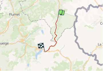

Length
20 km

Max alt
2515 m

Uphill gradient
1535 m
Km-Effort
38 km

Min alt
1176 m

Downhill gradient
836 m
Boucle
No
Creation date :
2025-07-17 06:35:15.965
Updated on :
2025-07-18 07:23:18.624
6h30
Difficulty : Very difficult

FREE GPS app for hiking
 SityTrail
IGN / Geographical institutes
SityTrail Plus
The world is yours!
About
Trail Walking of 20 km to be discovered at Auvergne-Rhône-Alpes, Upper Savoy, Les Contamines-Montjoie. This trail is proposed by yvesconnes.
Positioning
Country:
France
Region :
Auvergne-Rhône-Alpes
Department/Province :
Upper Savoy
Municipality :
Les Contamines-Montjoie
Location:
Unknown
Start:(Dec)
Start:(UTM)
322976 ; 5074626 (32T) N.
Comments